
Project Documents:
Document A
Document B
Document C
The Salt River Marsh is located in Chesterfield Township. The Salt River Watershed is part of the Anchor Bay watershed, with is part of the St. Clair River Area of Concern. The Anchor Bay watershed covers approximately 171 square miles, including Macomb & St. Clair Counties in Michigan. The Salt River watershed covers approximately 31 square miles. The headwaters rise just west of Rochmond, 17.9 miles of stream distance to the north. The Salt River flows south through Macomb County and enters the northwest portion of Anchor Bay at about Jefferson Avenue & Sugarbush Road.
This project is located along the east bank of the Salt River between Jefferson Avenue on the south and Callens Road on the north. Two state-owned areas were identified on the lower Salt River as providing good opportunities for habitat restoration. The downstream (southern) Area “A” is approximately 25.34 acres and the upstream (northern) Area “B” is 19.57 arcres. Areas “A” & “B” are located approximately one mile upstream of the mouth of the Salt River on Anchor Bay, in Macomb County, Michigan. The lower gradient is low and the project areas are significantly influenced bythe water level of Lake St. Clair.

The Salt River Restoration Objectives:
*Improve Aquatic Habitat
*Improve Overall Water Quality
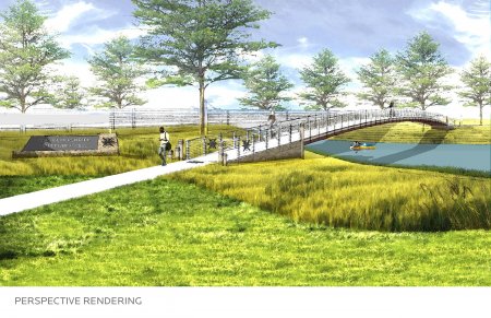
*Create Recreational and Educational Component for public use and enjoyment
*Provide a Sustainable Environment Corridor
The Salt River Marsh has become dominated by invasive Phragmites australis, drastically reducing valuable biodiversity and wildlife habitat critical to the success of a riparian ecosystem. This restoration plan looks to manage this invasive plant species and restore the native plant vegetation to facilitate a successful wetland habitat. Controlled burns can be used to manage the invasive plants and expose the existing native seed bank to allow for the emergent and submergent wetland flora to establish. Dredged channels provide both adequate depth for these native species and unfavorable conditions for the invasive plant to return. These channels will increase water flow through the wetlands and assist in water filtration contributing to improved overall water quality. Small perimeter channel pockets offer access to wooded wetland islands via kayak and create additional protected habitat for waterfowl, fish, amphibians and small mammals. The forested wetland islands offer boardwalk networks, picnic areas, scenic overlooks, and informative ecological signage for a unique, hands-on educational experience.
There are many uses along the Salt River, as well as many sights and sounds. The kayak experience along the Salt River offers a leisurely experience that winds through turn after turn of serene Michigan waterway. The diverse ecosystem and wildlife habitat creates an ever-changing user experience. The trail brings you close up and personal with rare marshland habitats and its calm waters make this an ideal trip for paddlers of all skill levels.
Here are more details on the water trail:
Checkpoint / Access: Situated along 23 Mile Road, World’s Finest Frozen Custard & Mini Golf serves as either a great destination or starting point for the Salt River Kayaking Experience. Frozen Custard offers parking, river access, mini golf, and frozen custard. This location marks a 2.5 mile checkpoint to Lake St. Clair, and can be the start of a journey towards the Lake St. Clair Coastal Water Trail, or simply a round-trip loop of the Salt River’s calm water.
Paddling Park Plan: Located along Jefferson Avenue, this former marina site offers the potential for a new paddling park on the shore of the Salt River. With a connection to the Macomb County Regional Trail Loop, this site will serve as a trailhead for paddlers and trail users, offering parking, restrooms, kayak rentals, pavilion shelter, wetland boardwalks, accessible kayak launch, and fishing pier.


Marina District: The Marina District is located at the mouth of the Salt River. Servicing Anchor Bay and the greater Lake St. Clair area, this marina is a hub for boaters of all types. A future kayak landing installation would provide one last potential stop before heading out onto the open water.


